Tuesday, May 13, 2008
Thursday, April 3, 2008
Lab 10 - Google Earth Map Overlays
This was a pretty easy lab. I kind of enjoyed it actually. Here's a tip though...make sure you use good quality maps. I fooled around with 2 or 3 that didn't work too well before I used these. Here is my .kmz file...
http://rkpalmerjr.googlepages.com/Lab_10_MapOverlays.kmz
Mt. Vernon Trail and Fountainhead Regional Park...

Mt. Vernon trail along the George Washington National Parkway...
.jpg)
Fountainhead Regional Park Mountain Bike Trails...
.jpg)
No more labs!!! On to the final projects...woohoo!!!
http://rkpalmerjr.googlepages.com/Lab_10_MapOverlays.kmz
Mt. Vernon Trail and Fountainhead Regional Park...

Mt. Vernon trail along the George Washington National Parkway...
.jpg)
Fountainhead Regional Park Mountain Bike Trails...
.jpg)
No more labs!!! On to the final projects...woohoo!!!
Tuesday, April 1, 2008
Map of Ludacris' Hoes
I came across this map on the strangemaps blog and thought it was too funny. I had to post it on my blog. Those of you who know the song will get it.

Here's what is said at strangemaps.wordpress.com...
"“I’m a female and a feminist. I dislike the usage of the word ‘ho’. However, as a geography major, I find this song hilarious, and had to map it,” says Stefanie Gray, referring to ‘Area Codes’ by the rap artist Ludacris.
Rap, for those less familiar with the term, is a genre in which the rhythmic delivery of rhyme and wordplay constitutes the main element of the music. Rap relates to singing as racewalking relates to running – but that’s just my inexpert opinion.
Rap music has been criticised for its content, which often consists of crude and ludicrous bragging about the rapper’s lyrical, financial, criminal, physical and sexual prowess. ‘Area Codes’ could be considered as an example of this phenomenon, sometimes referred to as gangsta rap:
“I’ll jump off the G4, we can meet outside/So control your hormones and keep your drawers on/’Til I close the door and I’m jumping your bones/3-1-2’s, 3-1-3’s (oh), 2-1-5’s, 8-0-three’s (oh)/Read your horoscope and eat some horderves (sic)/Ten on pump one, these hoes is self serve/7-5-7, 4-1-0’s, my cell phone just overloads.”
“In this song, Ludacris brags about the area codes where he knows women, whom he refers to as ‘hoes’,” says Ms Gray, who plotted out all the area codes mentioned in this song on a map of the United States. She arrived at some interesting conclusions as to the locations of this rapper’s preferred female companionship:
* “Ludacris heavily favors the East Coast to the West, save for Seattle, San Francisco, Sacramento, and Las Vegas.”
* “Ludacris travels frequently along the Boswash corridor.”
* “There is a ‘ho belt‘ phenomenon nearly synonymous with the ‘Bible Belt’.”
* “Ludacris has hoes in the entire state of Maryland.”
* “Ludacris has a disproportionate ho-zone in rural Nebraska. He might favor white women as much as he does black women, or perhaps, girls who farm.”
* “Ludacris’s ideal ‘ho-highway’ would be I-95.”
* “Ludacris has hoes in the Midway and Wake Islands. Only scientists are allowed to inhabit the Midway Islands, and only military personnel may inhabit the Wake Islands. Draw your own conclusion.”
Ludacris is not deterred by clever and/or strong women? The concept of Ludacris’ song reminds me a bit of ‘I’ve Been Everywhere’ by Johnny Cash, which, come to think of it, probably shares some subtext with ‘Area Codes’.
Map kindly provided by Stefanie Gray."
This post is at http://strangemaps.wordpress.com/2008/03/09/254-ludacris-rap-map-of-us-area-codes/
Friday, March 28, 2008
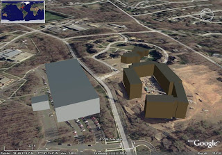
Lab 9 - Google Earth and Sketchup Cont...
Here's the link to my .kmz file. (This Google Pages stuff is awesome by the way)
http://rkpalmerjr.googlepages.com/Lab9_GMU_3D_RKPJr.kmz
It figures I would get stuck with buildings that did not exist when this satellite image was taken. Only one of these buildings were completed at the time. Sandy Creek Parking Deck is placed over a bunch of cars right now. I think the buildings actually look much better in the image from Sketchup.

.jpg)
.jpg)
.jpg)
Thursday, March 27, 2008
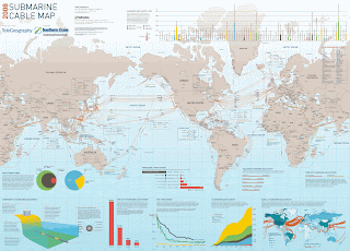
Map post...
I chose a map that wasn't actually displayed on that website, but that I found through a link from one that was. This one shows submarine cables going across major bodies of water. One of the things I really like about this map is the diagram and charts and mini map along the bottom. The diagram and the chart that shows submarine cable capacity on the bottom corners are especially interesting I thought, and really add to the entire map.

Lab 8 - Google Earth and Sketch Up
Here is the first part of Lab 8 - my Google Earth file.
http://rkpalmerjr.googlepages.com/Lab8Placemarks.kmz
Also here is my "geography tool of the future." Ummm, I guess its a 3D image table thing. Kind of like what they used to plan out the attack on Death Star in Star Wars. Wow...I'm a dork. Anyway, this one is looking at a city.

http://rkpalmerjr.googlepages.com/Lab8Placemarks.kmz
Also here is my "geography tool of the future." Ummm, I guess its a 3D image table thing. Kind of like what they used to plan out the attack on Death Star in Star Wars. Wow...I'm a dork. Anyway, this one is looking at a city.

Monday, March 10, 2008
Lab 7 - Shape Tweening...
This shape tweening stuff is pretty difficult. For some reason the front line in the south gets all funky. I don't know. After July 16th though it works almost perfectly. I'm tired of messing with it though as I've wasted the past 2 or 3 hours trying to fix it without success. Maybe later...
Link...http://img90.imageshack.us/img90/7946/lab7qu6.swf
Link...http://img90.imageshack.us/img90/7946/lab7qu6.swf
Saturday, March 8, 2008
Lab 6 - Operation Barbarrosa...
This was kind of a fun map to do. It was difficult trying to get the motion guides set up at first but after one or two it wasn't that bad.
Oh yeah, heres the link for the full size version...
http://img221.imageshack.us/my.php?image=lab6um9.swf&width=800
Oh yeah, heres the link for the full size version...
http://img221.imageshack.us/my.php?image=lab6um9.swf&width=800
Thursday, February 28, 2008

Thursday, February 21, 2008
Lab 5..."Faux-GIS"
Here's my Lab 5. It's gray and its a bit boring and ugly but whatever. I don't have as much time to spend on this one as I did Labs 3 and 4, but all my checkboxes and scripting and stuff works and that's the point of the lab, so this will do. One thing I wish I wouldn't have done is change the transparency percentages from the 20% it says to use in the lab handout. I figured if a state had to be filled in more than five times you wouldn't be able to tell the difference between five or six or more, but the problem with the way I have it now is that the color is too transparent when there's only one or two states filled in. Should've known. Oh well.
Link...http://img143.imageshack.us/img143/7249/lab5rc2.swf
Link...http://img143.imageshack.us/img143/7249/lab5rc2.swf
Monday, February 18, 2008
Map Brief - Interface Design for Interactive Maps - Martha & Kevin
The following information and sites talk more specifically about "web interface design" in general, but considering that maps like the ones we are making are being presented digitally and through the web, we think the criteria for good web interface design applies to good interface design for interactive maps as well.
-What is Interface Design and what is the goal of good interface design?
"Interface Design - The creation of a way for a customer, client, or visitor to interact with a product, be it a piece of software, instructional material, technical documentation, etc. The interface may take the form of a computer screen, a hand-held control panel, a set of pushbuttons, etc. Design of the interface is critical to the user's successful, positive experience with the product. Interface design encompasses an analysis of the needs and expectations of the user and the needs and tasks that the product is designed to help the user perform."
User-Centered Design - "The goal is to provide for the needs of all your potential users, adapting Web technology to their expectations and never requiring readers to conform to an interface that places unnecessary obstacles in their paths."
Sources: http://www.denow.com/6gloss/index.html,
http://webstyleguide.com/interface/user-centered.html
-What aspects make a good interface design for interactive maps?
Usability - "refers to how intuitively or easily your media item is navigated and processed (flow, sequence, instructions, download time). Note, this construct is the most inclusive of the three and is influenced by both visualization and functionality."
Visualization - "is creating visually interesting and aesthetically pleasing media items while avoiding potentially distracting or unncessary "bells and whistles."
Functionality - " refers to the features of your media item and how useful they are for supporting a given task (e.g., interactive simulations, drill and practice quizzes, site maps, frequently asked questions, search engines)."
Accessibility - " is an emerging Web interface design topic; if not addressed, it will negatively influence Web site usability for users with certain disabilities; tools that help users access your site in alternative formats (e.g., text, aural, visual) provide for increased functionality."
Source: http://www.edtech.vt.edu/edtech/id/interface/
Common Interface Design Considerations:
Layout
-What is your purpose? Display only or user interaction? Downloadable or View only?
-How much data do you have to communicate? Who is your audience?
-Dynamic user interaction OR a movie type animation?
-Single or Multiple Pages? (Keep it simple)
-Opening Intro/Splash page and Closing Page?
-Timeline on bottom or top, moving left to right through time
-How will the user interact with the timeline.....click, scroll, auto play with pre-defined stops?
--Do you have any additional info to provide when user clicks on dates on the timeline?
-Table of Contents or User manipulated layers on left
--How will the user toggle layers for viewing....pull down, check boxes, tab menu?
Buttons/Interface
-VCR buttons for stepping through the timeline sequence
--Play, Stop/Pause, FWD, REV
-Rollover effect (user provided info about particular button or graphic)
--Text box appears OR icon changes color, line width etc.
-Cursor changes from arrow to hand symbol to show user ability to do or select something
--audible clicks when user selects an option
-Scroll bar effect for text boxes
Interactive Map Examples:
The GOOD...
New York Times - Presidential Candidate Schedules
http://politics.nytimes.com/election-guide/2008/schedules/pastevents#candidate99
More maps from this cartographer...http://maps.grammata.com/
Dave Matthews Band 2002 Tour
http://www.mapbureau.com/tours/davematthews/flashindex.html
More from this company...http://www.mapbureau.com/
The NOT SO GOOD...
Jehovas Witnesses
http://www.ilabmedia.com/service_year/
More from this company...http://www.reddingwebdesign.com/maps/
Iditarod Map
http://www.iditarod.com/flashmap/
Additional Info...
Adobe sites of interest - Flash Design Center
This site provides all kinds of tutorials for the Adobe FLASH software suite. It also provides links to Blogs and Podcasts about using Flash with other applications and formats such as XML.
http://www.adobe.com/cfusion/designcenter/search.cfm?product=Flash&go=Go
This next link will take you to the subset of the above Flash Design Center that covers �interactivity.�
http://www.adobe.com/cfusion/designcenter/search.cfm?product=Flash&term=Flash&topic=Interactivity#target
Finally this one from Adobe covers �animation.�
http://www.adobe.com/cfusion/designcenter/search.cfm?product=Flash&term=Flash&topic=Animation#target
LUKAMARAS----The most detailed flash tutorials on the web!
http://www.lukamaras.com/index.html
http://www.lukamaras.com/tutorials/menus-interfaces/menus-buttons-interfaces-tutorials.html
Open Geospatial Consortium
The Open Geospatial Consortium, Inc (OGC) is an international industry consortium of 345 companies, government agencies and universities participating in a consensus process to develop publicly available interface specifications. OpenGIS� Specifications support interoperable solutions that "geo-enable" the Web, wireless and location-based services, and mainstream IT. The specifications empower technology developers to make complex spatial information and services accessible and useful with all kinds of applications.
http://www.opengeospatial.org/standards
http://www.opengeospatial.org/standards/bp
Thursday, February 14, 2008
Lab 4...A lot less time consuming than Lab 3!
This is my map updated with the interactive timeline and sounds we were supposed to add in Lab 3.b, AKA - Lab 4. I also realized that I never added in the Patriots record for each week for Lab 3. So I added that in there too this time. Here's the link...
http://img223.imageshack.us/my.php?image=lab4ui1.swf
I also just realized that the Patriots record is wrong because I didn't account for the bye weeks. I'll fix it later.
http://img223.imageshack.us/my.php?image=lab4ui1.swf
I also just realized that the Patriots record is wrong because I didn't account for the bye weeks. I'll fix it later.
Wednesday, February 13, 2008
Lab 3...My first "real" Flash map!
I uploaded my flash file onto the web using www.imageshack.us. We didn't do the Mason cluster account thing last semester after all, and looking it up now...it doesn't look like it is any easier to mess with this semester either, so I just did it this way instead. My map is "usable" as it is in blogger, its just smaller. If you want the bigger version go here...
http://img218.imageshack.us/my.php?image=lab3ig7.swf
http://img218.imageshack.us/my.php?image=lab3ig7.swf
Tuesday, February 5, 2008
Really cool color palette generator...
I just came across this really cool color palette generator. Basically you put in the url of any image on the website, and the generator spits out a set of colors based on the image. Check it out...I've also added it to my links...
http://www.degraeve.com/color-palette/
http://www.degraeve.com/color-palette/
Monday, February 4, 2008
Lab 2...Flash Intro

This lab took me a lot longer than it should have. I could have done this in Illustrator in half the time it took me to do it in Flash...
Monday, January 28, 2008
Lab Numero Uno...
Here are my JPEG images for the first lab...
Before the tsunami...

And After the tsunami...

Things I learned from my first exercise with Photoshop...
-It is less difficult (for me at least) to draw/paint/whatever moving the mouse in an "upward stroke" as opposed to moving the mouse down towards me.
-It is also less difficult to do the same thing moving the mouse to the right, out further away from me as opposed to moving the mouse to the left (I'm right handed).
-It really sucks not having a pen tool like in Illustrator to "connect the dots" or nodes.
-But...at the same time its nice to have an eraser in Photoshop too, which we all know doesn't exist in Illustrator.
Friday, January 25, 2008
Damn it Justin...
I just realized Justin posted the Middle East map already so heres another one...

It's a political map of the world through the eyes of a Tory. I got it off Strange Maps of course. Disclaimer: It is possible that someone may find this map slightly offensive. Whatever...it's satire. I would just like to make it clear however that even though I'm posting this on my blog, I'm not a Tory. Linky link...
http://strangemaps.wordpress.com/2007/04/17/105-the-tory-atlas-of-the-world/
Political Map...
Some of you all might have seen this map before but I'm going to post it anyway because I think its kind of interesting. It's a map of the hypothetical "New Middle East."

If you are interested in more info relating to the map, here's some links...
www.armedforcesjournal.com/2006/06/1833899
http://www.globalresearch.ca/index.php?context=viewArticle&code=NAZ20061116&articleId=3882

If you are interested in more info relating to the map, here's some links...
www.armedforcesjournal.com/2006/06/1833899
http://www.globalresearch.ca/index.php?context=viewArticle&code=NAZ20061116&articleId=3882
Hmmm...this looks familiar...
A new semester means a new blog! So while I decided to make a "new" blog with a fresh start, I'm keeping the look the same because well...I liked it the way it was before. If for some odd reason you haven't noticed, my blog from last semester is still at www.geog310rkpjr.blogspot.com. Intro to Digital Cartography was by far my favorite class last semester and I'm really looking forward to learning some more advanced cartography skills and how to use some of the other software out there like Photoshop and Flash. I think for the most part everybody produced some really cool stuff last semester and I'm excited to see what we come up with this semester as well.
Subscribe to:
Posts (Atom)